Erosion plan in the works for Queenscliff’s ‘Dog Beach’

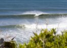
The Narrows, commonly referred to as 'Dog Beach', is a popular spot for residents to walk their dogs off-leash. Photo: BOROUGH OF QUEENSCLIFFE


QUEENSCLIFF community members can have their say on a coastal erosion management project that will examine the impact of erosion on the ‘Narrows’ linking Queenscliff and the Bellarine Peninisula.
The Department of Land Water and Planning (DEWLP) said erosion is impacting the dune system at Narrows Beach, also known as ‘Dog Beach’.
To mitigate effects, DEWLP is working with the Borough of Queenscliffe and key stakeholders to better understand the hazards, risks, and adaptation options for the site.
“Coastal erosion is a naturally occurring challenge facing many areas across Victoria. In locations where it is negatively impacting important assets, we develop adaptation plans to manage the impacts,” DELWP regional manager Gavan Mathieson said.
“We’re really keen to work with locals to discuss the science so
everyone has a good understanding of the natural processes at work here and what the realistic management options are.”
The authority will follow a pathway approach identified in the Marine and Coastal Policy (2020) to inform the development of management of the area over time, and will investigate coastal processes, asset vulnerability and hazard maps and an adaptation options assessment.
DEWLP will identify trigger points that will prompt realistic short and longer-term adaptation actions for authorities to manage over time.
Additional wave monitoring buoys have been installed in Port Phillip Bay to inform and help understand sand movement and erosion events.
“Adapting to climate change is a challenge for coastal areas, which are in some ways at the frontline,” Mr Mathieson said.
“It’s about getting the facts on the table and identifying what options we have to protect critical assets and how we adapt to changes long-term.”
The department hosted a Listening Post at Narrows Beach on Sunday to hear from residents about how they utilise the beach and what improvements could be made to the area.
The Marine and Coastal Policy 2020 guides decision makers in the planning, management and sustainable use of the coastal environment, providing direction to decision makers
including local councils and land managers on a range of issues including dealing with the impacts of coastal hazards.
Community engagement will open next week at www.engage.vic.gov.au
Share


Related Articles
Liberals defend safety of 110kmh freeway plan
The Liberals have dismissed concerns their proposed 110kmh speed limit…
Teachers walk off the job for second time as AEU pushes government for deal
Victorian public school teachers will strike for the second time…