Power out as dangerous storms hit Northern Rivers
A dangerous thunderstorm has hit the Northern Rivers, with a warning in place at 3:41pm on Monday 24 November 2025


A VERY dangerous thunderstorm has hit the Northern Rivers, with a warning in place at 3:41pm on Monday 24 November 2025.
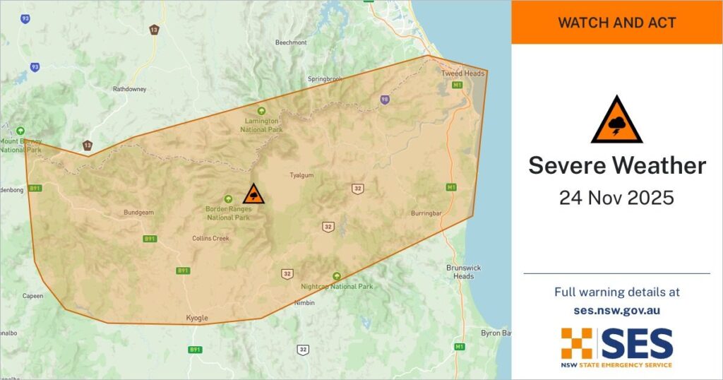
The NSW SES urged residents in several towns to stay indoors as severe weather moved across the region.
The SES advised people in Tweed Heads, Murwillumbah, Kyogle, Hastings Point, Numinbah, Tyalgum and surrounding areas to STAY INDOORS due to heavy rainfall, damaging winds, giant hailstones and flash flooding.

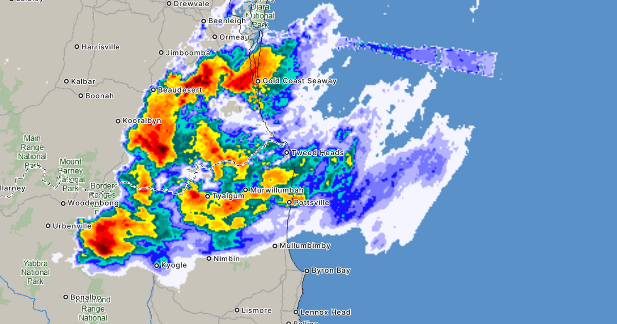
“4 to 5 cm hail observed at Murwillumbah at 2:35 pm,” the statement issued at 3:41pm read.
“You should monitor the situation as it is constantly changing.”
A warm and humid airmass is combining with a southerly wind change and a low pressure trough to trigger severe thunderstorms across the region this afternoon.
“Severe thunderstorms are generally moving to the north and northeast and are expected to contract towards the Queensland border.”
“VERY DANGEROUS THUNDERSTORMS are likely to produce large, possibly giant hailstones, damaging wind gusts and heavy rainfall that may lead to flash flooding over the next several hours in parts of the Northern Rivers and Northern Tablelands districts.”
“This event may change quickly. NSW SES will monitor the situation and update warnings if the situation changes.”
Power outages have been reported across parts of the region as the storms move north and northeast.
Residents are urged to stay indoors, monitor updates and avoid travel in affected areas.
For emergency assistance during a flood, storm or tsunami, call the NSW SES on 132 500.In a life threatening emergency, call Triple Zero.

Earlier today the Bureau of Meteorology issued a severe heatwave warning for the Northern Rivers, with temperatures set to climb into the mid to high thirties across the first half of the week.
The warning covers the Northern Rivers, Mid North Coast, Northern Tablelands and Upper Western.
Daytime temperatures of 30 to 35 were forecast for Monday, with similar conditions expected on Tuesday.
Wednesday is expected to be the peak of the heatwave, with temperatures between 32 and 37 across the region.
Severe heatwave conditions are likely to ease in the west early to mid week but persist longer in the northeast.
Story first published at 3.50pm Monday 24 November
Update 4.20pm Monday 24 November
Share


Related Articles

Children’s Ward receives new phototherapy lights
LISMORE Base Hospital’s Children’s Ward has received two new phototherapy…
Art exhibition to highlight end of an era at town and gown event
THE annual Lennox Head Lions Town and Gown Art Exhibition…