Breaking: updated flood and severe thunderstorm warnings across the Northern Rivers
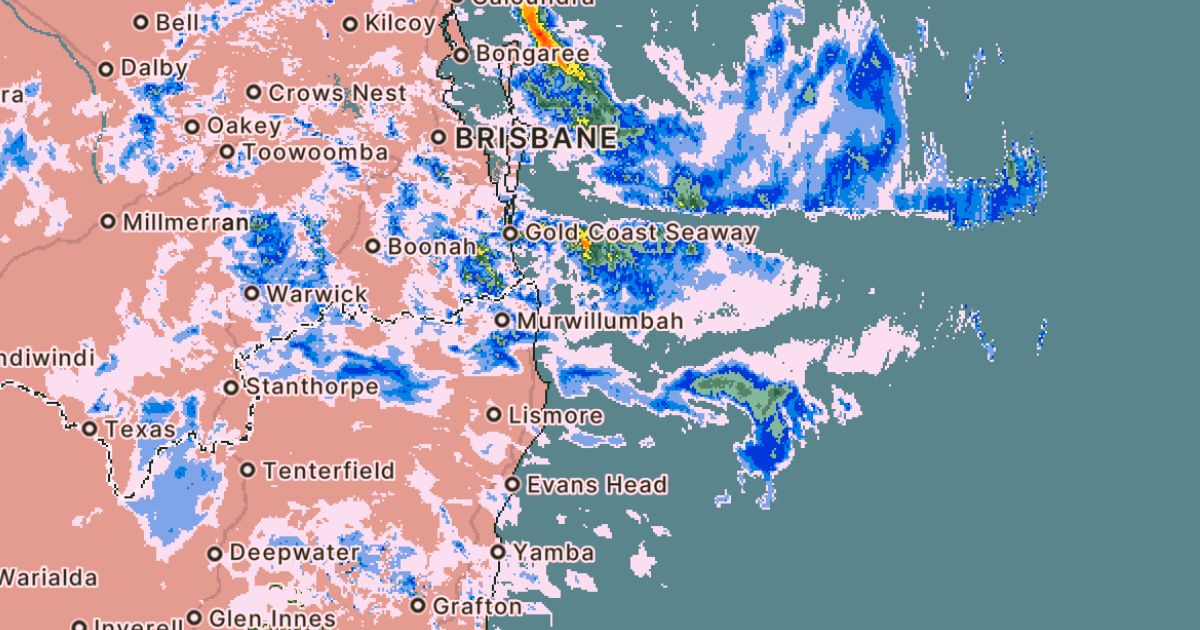
Bureau of Meteorology weather radar shows widespread rainfall across the Northern Rivers at 2.03pm on Friday. Photo: SUPPLIED


Flood and severe thunderstorm warnings for heavy rainfall remain current this afternoon across parts of the Northern Forecast District, with strong wind warnings also in place for the Byron Coast.
Between Friday and Sunday, up to 220mm of rainfall is forecast at the upper end of the range in parts of the Northern Rivers. Forecast totals include up to 220mm in Tweed Heads, 165mm in Byron Bay, 135mm in Ballina and 115mm in Lismore.
Since 9am Thursday, widespread rainfall totals of 100 to 150mm have been recorded across Flood Watch catchments, with isolated falls exceeding 200mm, leading to rising river levels in affected areas.
Moderate to locally heavy rainfall is forecast to continue through Friday afternoon and across the weekend, with further river level rises and isolated minor flooding possible from late Friday.
Catchments across the Northern Rivers remain moderately wet following recent rainfall, increasing the risk of localised river rises and flash flooding in areas experiencing the heaviest falls.
The impacts are already being felt, with The Pocket Road closed due to the risk of a major culvert collapse following rapidly rising water levels from the ongoing rain event.
Byron Shire Council closed the road on Friday after assessments found the steel culvert structure between 860 and 879 The Pocket Road faces a high risk of failure during major rain events.
“Overnight, more than 100 mm of rain fell in under three hours (calculated at the Helen Street Bridge gauge). Several causeways and culverts across the shire are now overtopping and already unsafe to cross,” Director Infrastructure Services Phil Holloway said.
“The rainfall we’ve had overnight has indicated the risk of collapse is too significant, and if we don’t act early, we can’t guarantee the safety of nearby residents and infrastructure,” he said.
The road is expected to remain closed until the current rain event passes, anticipated to be Monday morning, with engineers to inspect the site as soon as conditions allow. Barriers and signage are in place, and motorists are urged to use alternative routes and avoid the affected structure.
Flood classes including minor, moderate and major are only defined for catchments where the Bureau provides a flood warning service.
Residents are urged to avoid floodwater, stay away from swollen rivers and drains, obey road closures and monitor local media for updates as conditions can change quickly.
For the latest flood and weather warnings visit
bom.gov.au/weather-and-climate/warnings-and-alerts
For rainfall and river level information visit
For coastal wind, wave and weather conditions visit
bom.gov.au/nsw/forecasts/map.shtml
For local emergency warnings and advice visit
The next Severe Thunderstorm or wind warning will be issued by 4:05pm AEDT Friday, February 13.
The next Flood Watch will be issued by 1pm AEDT Saturday, February 14, 2026.
Share


Related Articles

Gordon Ramsay-trained chef Elizabeth O’Brien takes over at refurbished Crystalbrook Resort restaurant
SHE honed her skills at the local RSL and worked…
Tumbulgum’s century-old hall stands strong after repeated floods
MORE than a century after locals built Tumbulgum Hall, the…