Committee for Lorne: Reedy Island


Reedy Island: an echo from the past
For joy! … the island is back … though don’t blink or you will miss it.
Just like the wreck of the Otway that so briefly appeared at the river mouth after the flood and then slipped silently back under the sands, the island may yet rejoin the river bank and return to its hiding place.
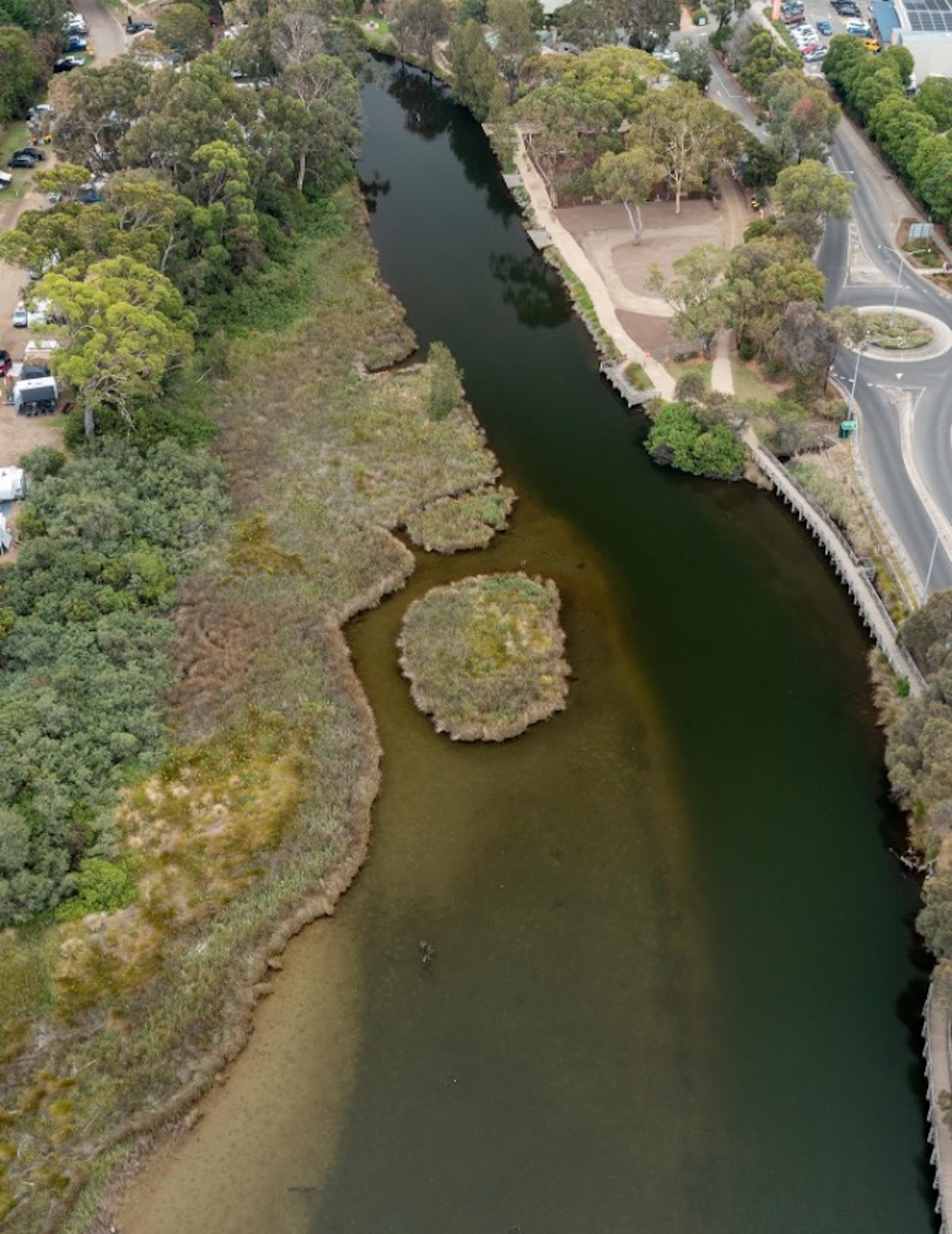
Jonn Stewart [our Foodworks supremo] answered my ‘drone-please-Jonn’ photo plea by taking this stunning seen-from-above photo of the newly-sculpted island in the Erskine … so, thank you, Jonn.
It shows a well-demarcated island hard against the eastern shore of the lower Erskine, where, until recently, no such separation from the bank existed. It shows, superbly, how water flow [and floods] can remodel a river’s topography.
Indeed, back in the day, the Erskine River followed a slightly different course—at least until it was nudged towards the eastern bank when the Lorne Foreshore Committee backfilled the river to widen the area available for camping.
Footnote: Some will still recall the days when the Foreshore Committee—comprising local elected representatives and only loosely overseen by the Winchelsea Shire Council—once held all the power in Lorne. I, for one, still regret its passing.
The effects of this recent deluge and the many past floods to which the river is prone have seen several features of the lower Erskine come and go over time as the river continues to remodel itself. Chief among these have been its islands. Every flood leaves a different river behind it, and the Erskine has seen plenty of these changes in Lorne’s settled history. The recent ‘catastrophic weather event’—as the media have now re-branded heavy rain—was not the first, not the worst, and certainly will not be the last.
While I abhor the current fad for claiming ‘victimhood’ at every slight, at every ‘event’ [NB: the media’s word], Lorne and Wye River have recently been community victims at the hands of sadly misinformed and lazy media whose reporting has wrought far more damage on both towns than either flood [brief], or fire [~50km distant at Carlisle River] could claim to have done.
Lorne’s excellent historical records yield a long list of damaging deluges dating back to the 1850s, several of which clearly far exceeded our ‘flash flood’. Perhaps the only distinguishing feature of this brief but impressive recent torrent was its suddenness, though the damage was tightly confined to the river beds and banks, leaving the town[s] largely unscathed.
Although 180mm fell in 6 hours within a concentrated area at Mt Cowley [10km to Lorne’s west], my rain gauge recorded a mere 8mm in the encompassing 24 hours. While clearly cold comfort to those who lost possessions in the caravan parks that dot our coastal river edges at Kennett, Wye, Separation, Cumberland, and Lorne, the towns did not deserve the pariah ‘flood-and-fire’ status accorded them by loose press reporting. The damage has been to business income, not to coastal infrastructure, and it continues to this day. As news organisations seek their ratings, they should be far more cognisant of the damage their reports can do to local communities.
But, back to the river’s remodelling process and to the island[s] come and go in the lower Erskine with each inundation. Once, there were at least two prominent islands in the broad section below the present-day caravan park and above the swing bridge. In my lifetime, I recall only one, though even that has not been clearly demarcated for several decades—at least until now.
I have been unable to determine whether it [or they] have ever been formally named, though I am sure they must have been. I dimly recall my gran calling the larger one ‘Reedy [or was it Rush] Island’. Pete Spring recalls the name ‘Sluggy Island’.
Whatever the case, when I was very young, I recall that an island stood centre-stream directly below our open verandah. A single reference [c.1878] in the Anderson Family notes [Lorne Historical Society: p.147] states: “… the men who worked for grandfather were paid 8/- a day, and they lived in tents on the hillside. The kilns were thatched with the rushy grass growing on the islands near the Erskine at its mouth”, though I shudder at the thought of thatching a kiln!
The first undated, age-stained photo of the early Erskine clearly shows two islands.
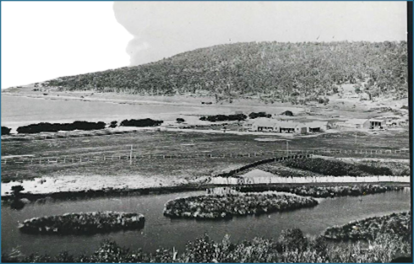
The second photo [also undated] shows the larger island in the distance in a wider, very differently shaped river estuary.
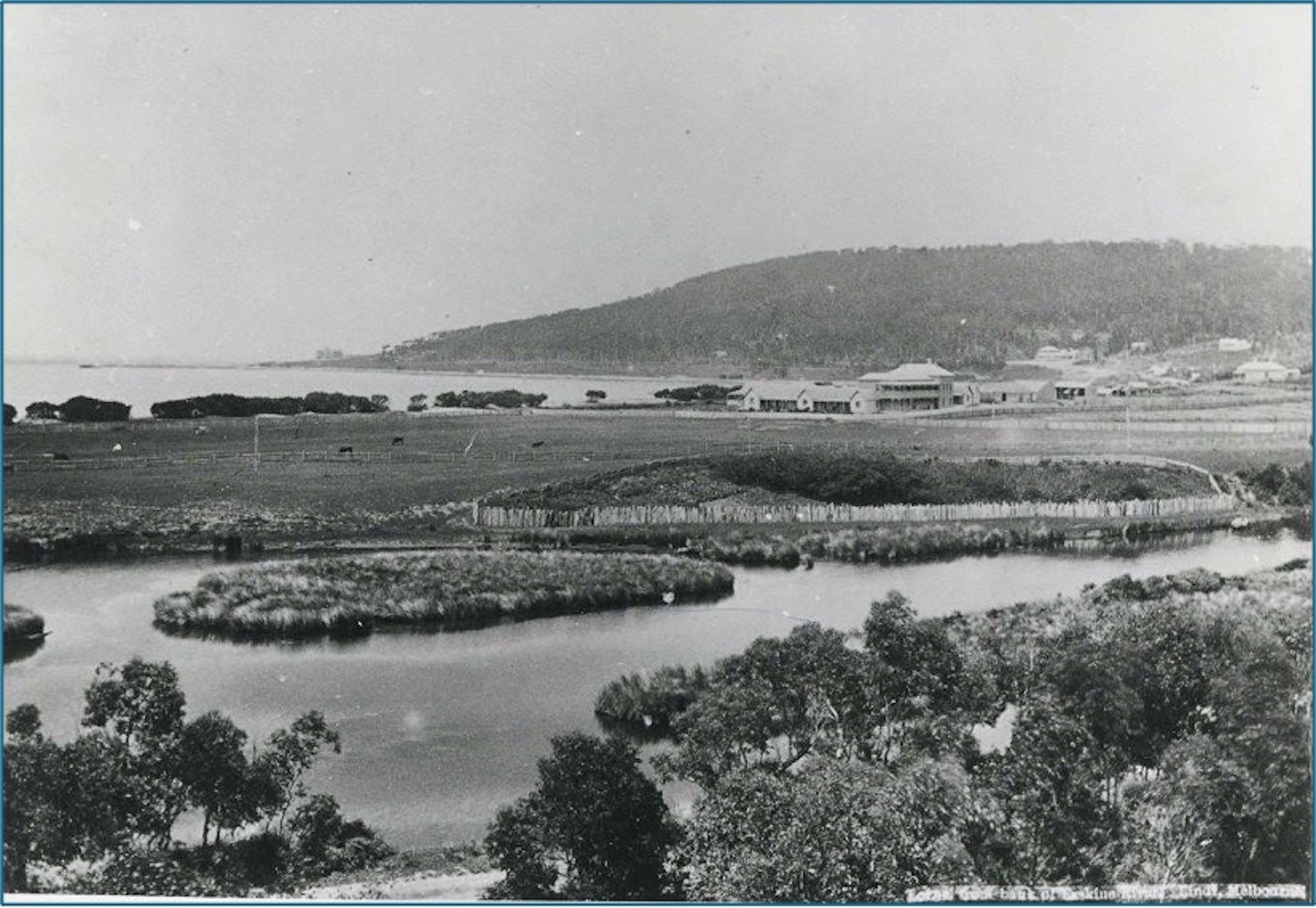
The third, [taken later as Mountjoy’s farm has a two-story guesthouse addition], shows the larger island denuded of rushes, presumably used by the Andersons when making bricks for the Gwynne’s Grand Pacific Hotel, which is now visible in the far distance.
When I was little, I remember watching—not without a touch of envy—the local kids playing ‘Pirates’ and ‘Treasure Island’, punting rafts made from planks and 4-gallon drums across to the bigger island to ‘claim possession’. I was too small to join, and although my gran was very much ‘local’ having lived exclusively in Lorne since 1915, I was then just a weekend-and-holiday ‘blow-in’ and never what is ‘one of the gang’.
It is uncertain whether the recently re-formed island will last, though I doubt it. The small channel that marks its eastern bank seems to be already silting up, and as the reeds regrow, it will inevitably merge back into the bank from which it has been briefly carved. Nevertheless, if I were still a kid, I think I would be busily crafting a skull and crossbones flag, building a drum and plank raft, and assembling a crew of mates to help me claim it as my own before—like the wreck at the river mouth—it disappears again.
However, any kid who tries a land claim these days would probably face the full force of the GORCAPA juggernaut. True to form, I fear its bureaucrats would step in and demand an OH&S safety report, an indigenous inspection for artefacts, an engineer’s report, a fire [and flood] evacuation plan, and multiple other forms filled out in triplicate before he could occupy ‘his land’.
Sadly, it seems that ‘kids having fun’ is now all too easily overshadowed by rules and regulations designed to ‘keep everyone safe’, but that said, there could be a more practical problem with Reedy [or Sluggy] Island … it is now likely a cosy little haven for snakes!
John Agar
Feature Writer
A word from the chairman
Hello
Lorne celebrated the March long weekend (quaintly still referred to as Labour Day but gradually morphing into International Women’s Day!) in style. Good weather brought many visitors to town; parking was at a premium and there were queues for coffee, drinks and food, but we did not complain as it was good to see our town busy again after a disrupted summer. Our Foreshore Market was back again after being cancelled in January due to extreme fire danger. The market is an important fundraiser for our local school, and it was great to see the many artists and artisans showcasing their creations and lots of locals and visitors exploring the offerings. All our hospitality venues were booked out and there was live music at several venues, including the iconic Joe Camilleri and the Black Sorrows at the Lorne Theatre. It is great to see the old girl jumping again! It was great to also see the beach so busy with the water temperature sitting at a year-high of 19 degrees.
Unfortunately, it was not such a good weekend for our cricketers who lost to our Apollo Bay neighbours in the preliminary final with some of our players taking away bruises as souvenirs. The Club has now completed four seasons since its resurrection (including two Grand Final appearances) and has developed into a team with a good mix of experienced players and some young talent, which holds them in good stead for the future. Well done to President Rip and all the boys on another great season.
In case you haven’t noticed, football is back in the air and saturating the media. On the local front, the Dolphins senior footballers have a practice match against Thomson (GDFNL) at Stribling Reserve on Friday, March 20 starting at 6.15pm (Bar and BBQ from 5.30pm). The first full round of football and netball games will be on Good Friday, April 3. Come along and check out this year’s exciting talent.
As we head into autumn, Forest Fire Management Victoria (FFMV) will again be conducting planned burning in the Otways when conditions are suitable. Lorne and surrounding areas are among the most vulnerable to bushfires in Victoria, and fuel management in public parks and forests is an essential part of the strategy to reduce the risk of bushfire to people, property and the environment. You can find more information about planned burns at www.ffm.vic.gov.au and more advice will be provided when burn dates have been determined.
And a little prayer for you on St Patricks Day:
“Grant me the senility to forget the people I never liked anyway, the good fortune to run into the ones I do, and the eyesight to tell the difference”.
Cheers
Lorne Ward Events Calendar
March
9-22 Artist in Residence (AIR) Joshua James, at Lorne Community Connect
Workshops focusing on explaining the process of design and symbols within his artwork. Saturday 14 + 21 Mar, plus Sunday 15 + 22 Mar 10 am – 11 am.
22 Deans Marsh Festival, Live music, local harvest, market stalls, dog jumping, kids events and much more. 10am – 3pm at Deans Marsh Reserve.
27 Lorne Anzac Memorial Park Official Opening @2pm
April
2 – 12 Photographic Exhibition Opening, at Lorne Community Connect + prize giving 5.30 pm.
3 Lorne Dolphins Football and Netball V Apollo Bay, at Stribling Reserve, juniors match from 8:45am, seniors at 2pm
4 Lorne Market, 9-3pm www.lornemarkets.com
3-12 Photographic Exhibition, at Lorne Community Connect 10 am – 5 pm.
Share


Related Articles
Neighbourhood Watch calls for Armstrong Creek police station
ARMSTRONG Creek’s Neighbourhood Watch believes the growth area is big…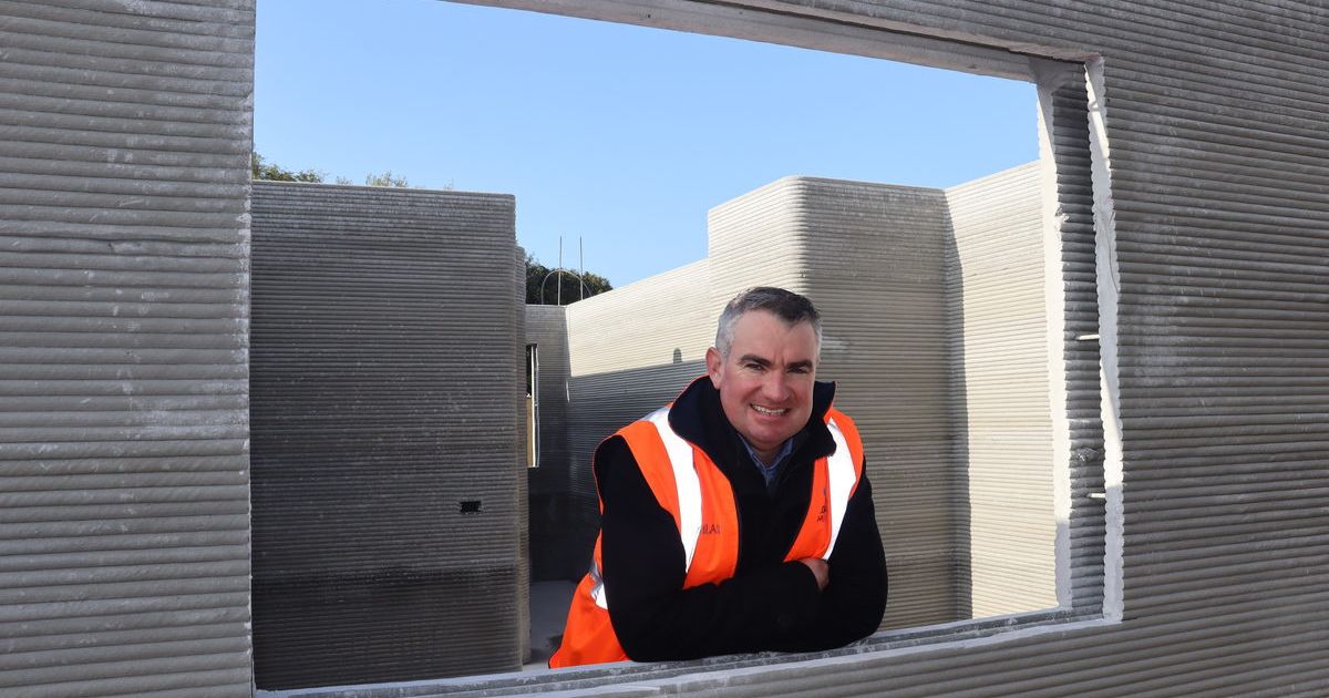
The printer that could transform home building
TWO social housing homes in Norlane have had their walls…